
UPDATED The National Weather Service has issued a flash flood warning for Montgomery County until 9 p.m. tonight (July 10). Doppler radar indicates a line of storms approaching the county that will be capable of producing flooding rains, according to a Montgomery County alert message. ORIGINAL POST The National Weather Service has issued a flash […]
flash flood watch


July 3, 2014 |
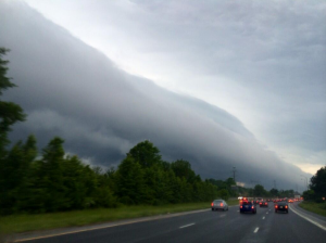
Weather Alert: Flash Flood Watch, Severe Thunderstorm Watch, Hurricane Arthur
UPDATED 7/3/14 at 2 p.m. The National Weather Service has issued a severe thunderstorm watch for Montgomery County. Severe thunderstorms are possible this afternoon and evening. ORIGINAL POST The National Weather Service (NWS) reports that Tropical Storm Arthur strengthened overnight and was upgraded to a hurricane early this morning (July 3). Hurricane Arthur is forecast […]
June 10, 2014 |
NWS Issues Flash Flood Watch for Montgomery County
The National Weather Service has issued a flash flood watch for Montgomery County from now until 2 a.m. on June 11. According to the NWS, thunderstorms that form during this period will be capable of producing flooding rains. Residents should expect extremely heavy rain that will flood low lying areas and streets with slow drainage. […]
June 18, 2013 |
NWS Issues Flash Flood Watch for Montgomery County
The National Weather Service (NWS) has issued a flash flood watch for Montgomery County until 6 p.m. on June 18. Heavy rain may have the potential to cause severe and unexpected flooding within the next 24 hours. Flash Floods kill more people every year than any other weather hazard. Do not drive through flooded areas. […]
June 12, 2013 |
Tornado Warning & Severe Thunderstorm Warning
June 13 @ 6:00 p.m. After the severe storm passed through, the National Weather Service issued a Flood Warning for Montgomery County. Residents should not try to cross flooded roads. Flooded areas may be harder to identify at night so use caution while driving. Update June 13 @ 3:53 p.m. The National Weather Service issued […]
June 10, 2013 |
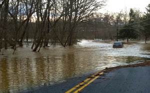
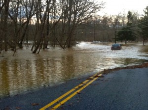
Seneca Creek Flood Warning
Updated Monday, June 10 at 11:15 a.m. The NWS has issued a Flood Warning for Seneca Creek at Dawsonville through late tonight. According to the NWS, as of 11 a.m. this morning Seneca Creek’s stage was 8.3 ft. and flood stage is 7.5 ft. Updated Monday, June 10 at 9:30 a.m. The National Weather Service […]
June 10, 2013 |
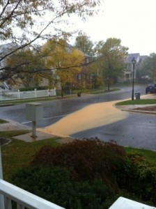
Flash Flood Watch
Updated Monday, June 10 at 9:30 a.m. The National Weather Service has issued a Flash Flood Watch for Montgomery County through 5 p.m. According to the national Weather service, additional showers and thunderstorms this afternoon and evening will produce 1 to 3 more inches of rainfall. With the ground already saturated from previous rainfall, it […]
January 30, 2013 |
Storm Safety Tips
The National Weather Service (NWS) has issued a flash flood watch for Montgomery County, for this afternoon through late tonight. Storms that bring heavy rain, damaging winds, and flooding are possible today. Here are some safety tips to keep in mind during these weather events. Heavy Rain and Flooding Many roads in the county are […]
January 30, 2013 |
Flash Flood Warning & Tornado Watch
The National Weather Service (NWS) has issued a flash flood warning for Montgomery County until 12:30 a.m. and a tornado watch until 2 a.m. on Jan. 31 (Thursday). Doppler radar indicates a line of storms approaching the county are capable of producing flooding rains. Residents should expect extremely heavy rain that will flood low lying […]
Engage us on Facebook
Follow us on Twitter
Tweets by @mymcmedia