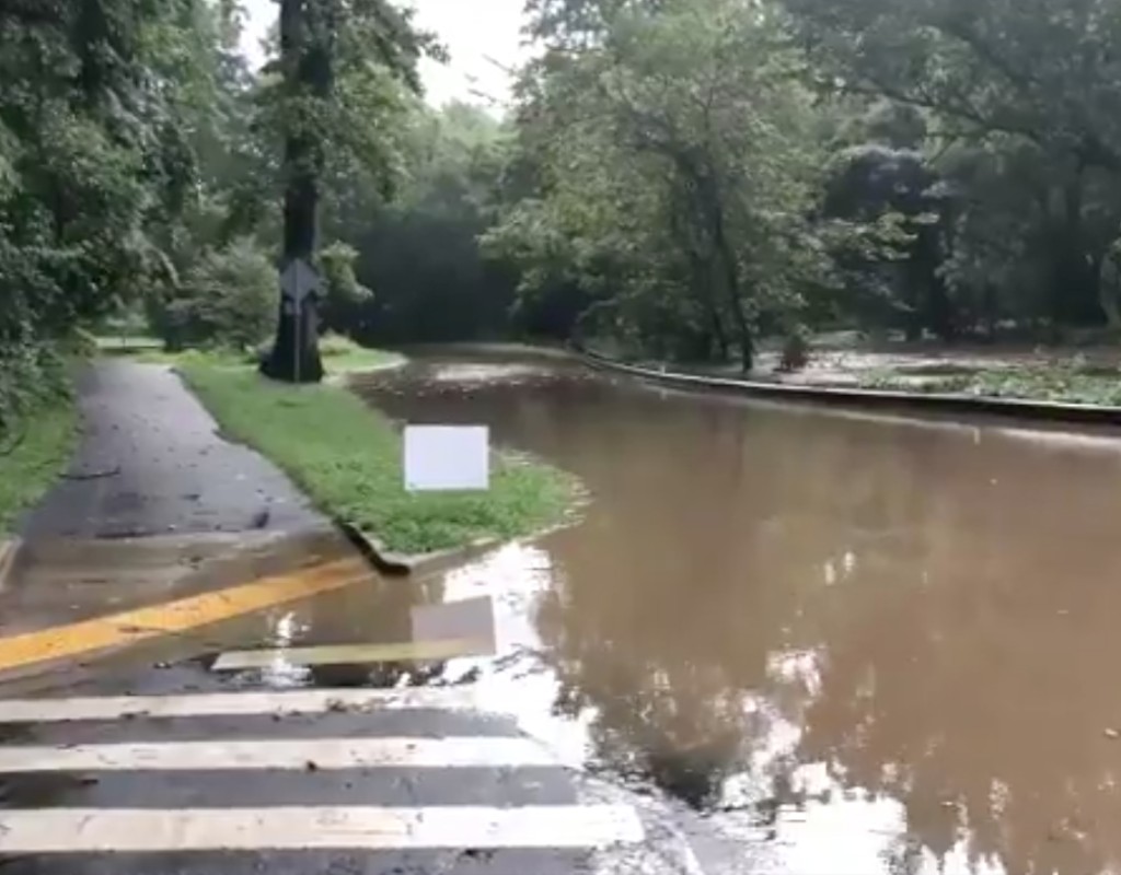
Thursday Evening Storm Caused High Waters, Put Fire and Rescue on Condition Red
On Thursday parts of Montgomery County were under a Severe Thunderstorm Warning, Tornado Warning and/or Flash Flood Warning.
Storms passed through the county and caused power outages, road closures and flooding. Montgomery County Fire and Rescue Service (MCFRS) Chief Spokesperson Pete Piringer said MCFRS was on “Condition Red” because so many calls were coming in about lightning, cars in water, wires down and more. Piringer said emergency communications answered about 50 to 60 calls between 4:30 p.m. to 5:30 p.m. Thursday, about one every minute. Overall, MCFRS responded to 361 incidents on Thursday, he said.
Rockville, Gaithersburg, Kensington and Silver Spring were some affected areas. Piringer tweeted that Beach Drive, in the Kensington area, was closed due to high water from Grosvenor Lane to Stoneybrook Drive. Parts of Sligo Creek Parkway in Silver Spring and Takoma Park were also closed.
The National Weather Service (NWS) Baltimore/Washington said as of Thursday night all strong thunderstorms and tornadoes had passed and as of early Friday morning, all flood warnings had expired. Montgomery Parks tweeted Friday morning that all natural surface trails are closed and many athletic fields are closed.
0.30” of rain in only 3 minutes in Montgomery County, MD #wx #MdWx pic.twitter.com/aiVt1sMf4D
— Carolyn Raskauskas (@CarolynRask) September 3, 2020
0.78” in 20 minutes in Montgomery County, MD #wx #MdWx @NWS_BaltWash Storm Spotter #MO004 pic.twitter.com/d9wMuiiVFu
— Carolyn Raskauskas (@CarolynRask) September 3, 2020
Rain was heavy in Gaithersburg and the storm drains were overflowing @dougkammerer @nbcwashington pic.twitter.com/YXUs4pDC6K
— Julia H. Jackson (@juliahanley) September 3, 2020
Traffic Advisory – Road Closed – Beach Drive IAO Kensington Parkway, Kensington/ N Chevy Chase pic.twitter.com/cn587szXS9
— Pete Piringer (@mcfrsPIO) September 3, 2020
Beach Dr CLOSED – high water From Grosvenor Lane to Stoneybrook Dr (video taken at W Stanhope Rd and Beach Dr just east of Connecticut Ave.) Flood Warning @MontgomeryCoMD pic.twitter.com/NgTt5iEYUa
— Pete Piringer (@mcfrsPIO) September 3, 2020
ICYMI – Traffic Advisory – portions of Sligo Creek Parkway in Silver Spring & Takoma Park CLOSED due to high water https://t.co/3uTouqDziw pic.twitter.com/0yp7yGn0PW
— Pete Piringer (@mcfrsPIO) September 4, 2020
— Anna-Lysa Gayle (@AnnaLysaGayle) September 4, 2020
The threat for strong to severe thunderstorms and tornadoes has ended. A few flood warnings are still in effect for parts of our region due to lingering effects from multiple rounds of storms. pic.twitter.com/Rna1xi712T
— NWS Baltimore-Washington (@NWS_BaltWash) September 4, 2020
All flood warnings have now expired, with mostly clear skies expected overnight. Low temperatures will be slightly above average, staying in the mid-upper 60s west of the I-95 corridor, while areas along/east of I-95 stay in the low 70s. pic.twitter.com/Ei0GgAjWfj
— NWS Baltimore-Washington (@NWS_BaltWash) September 4, 2020
Wow! Look at all this water 💦 My dad sent me this picture from yesterday’s storm in Silver Spring. He measured 2 and 3/4” of rain in 30 minutes! pic.twitter.com/j3nIeMxRhb
— Eileen Whelan (@Eileen7News) September 4, 2020
UPDATE
Following the storms last night, we have these updates:
TRAILS: All natural surface trails are closed. Please use caution on hard surface trails.
ATHLETIC FIELDS: Many athletic fields are closed.
Before leaving home, check RainoutLine : https://t.co/uECfdbdSP6. pic.twitter.com/QfSV5kr30R
— Montgomery Parks (@MontgomeryParks) September 4, 2020
Good morning! 1.2” of rain fell yesterday in Darnestown, MD pic.twitter.com/tNNVUmMp1Z
— Carolyn Raskauskas (@CarolynRask) September 4, 2020


Engage us on Facebook
Follow us on Twitter
Tweets by @mymcmedia