Florence Getting More Organized As It Heads for U.S. Coast
The National Hurricane Center said Tuesday afternoon that Hurricane Florence, packing 130 mph winds, was getting more organized and increasing in size.
The earliest reasonable time that tropical-storm-force winds could arrive in the United States from #Florence is late Wednesday, and the most likely time is Thursday morning. Wednesday should be the last full day to prepare, so plan accordingly. https://t.co/tW4KeGdBFb pic.twitter.com/eD2onAT1sd
— National Hurricane Center (@NHC_Atlantic) September 11, 2018
The storm traveling 17 mph heading toward the Carolinas was about 1,700 miles from Rockville.
The Category 4 hurricane forced storm surge watches along the coast, as far north as the North Carolina-Virginia border. A Storm Surge Watch means there is a possibility of life-threatening inundation, from rising water moving inland from the coastline, in the indicated locations during the next 48 hours, according to the hurricane center.
“Interests elsewhere in the southeastern and mid-Atlantic states should monitor the progress of Florence,” the center said.
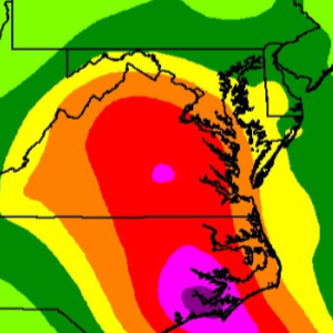
#Florence could produce life-threatening, catastrophic flash flooding & significant river flooding over portions of the Carolinas and Mid-Atlantic states from late this week into early next week. Graphic via @NWSWPC, and the full advisory is at https://t.co/tW4KeGdBFb pic.twitter.com/0bQAIiBMKZ
— National Hurricane Center (@NHC_Atlantic) September 11, 2018
The storm is traveling in a west-northwestward to northwestward path, expecting to increase in speed in the next couple of days, hurricane center said.
On the forecast track, the center of Florence will move over the southwestern Atlantic Ocean between Bermuda and the Bahamas through Wednesday and approach the coast of North Carolina or South Carolina in the hurricane watch area Thursday and Friday.
“Florence is expected to begin re-strengthening later today and continue a slow strengthening trend for the next day or so. While some weakening is expected on Thursday, Florence is expected to be an extremely dangerous major hurricane through landfall,” the hurricane center said.
For more information on the local hazards from #Florence, follow the @NWS offices on Twitter: @NWSCharlestonSC @NWSMoreheadCity @NWSRaleigh @NWSWilmingtonNC @NWSColumbia @NWSGSP @NWSWakefieldVA @NWSBlacksburg @NWS_BaltWash @NWS @NWSCharlestonWV pic.twitter.com/LNh3TGvCcd
— National Hurricane Center (@NHC_Atlantic) September 11, 2018

Engage us on Facebook
Follow us on Twitter
Tweets by @mymcmedia